
Denver’s mountain parks came into being in 1912, grew up with the new fad of the automobile, and have become familiar to all. Many visitors don’t know that, in creating the mountain park system, Denver first had to build roads for citizens to get to their new parks. Between 1914 and 1920, the City began to promote a series of “scenic circle trips” to help Denverites explore the mountains.
The Scenic Circles
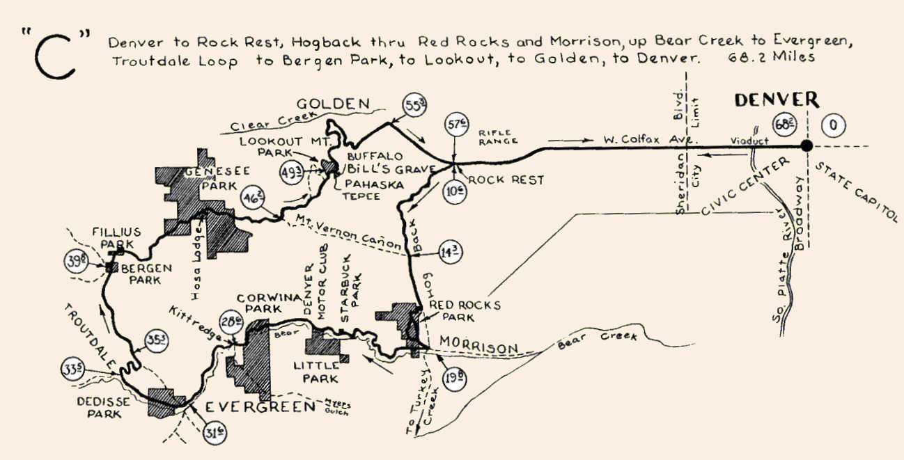
- Circle C. A clockwise circle from Denver to Rock Rest, south along hogback to Morrison, Bear Creek Canyon to Evergreen, north over Lookout Mountain, return to Rock Rest and Denver via Golden.
Map of Circle C, 68.2 miles.
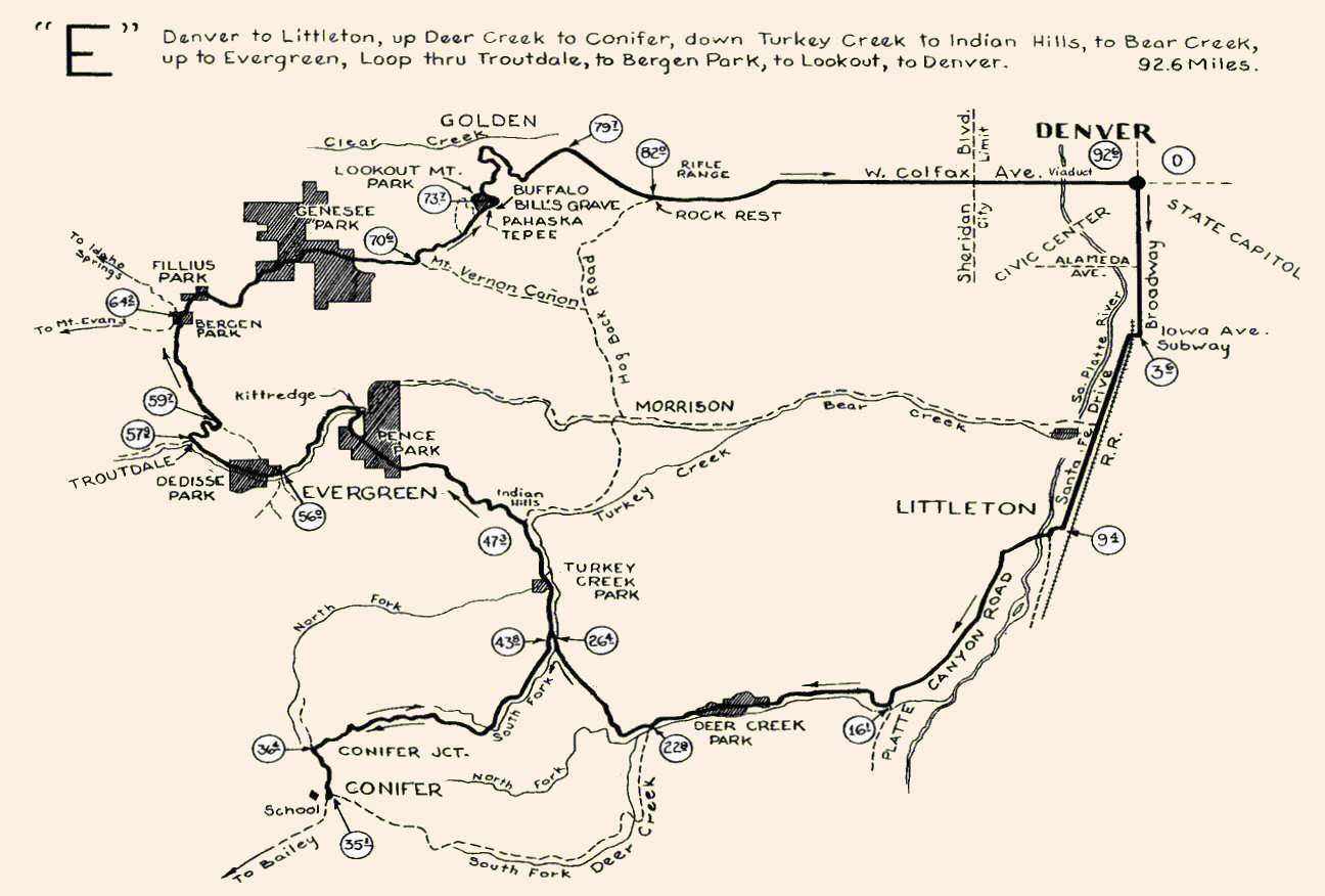
- Circle E. A clockwise circle from Denver out Platte Canyon Road to Deer Creek Canyon, north along South Fork of Turkey Creek, with a side trip west to Conifer and back, then northwest to Evergreen, north to Lookout Mountain, Golden, and return to Denver via Rock Rest.
Map of Circle E, 92.6 miles.
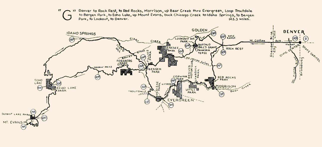
- Circle G. A double loop from Denver to Rock Rest, south along hogback to Morrison, Bear Creek Canyon to Evergreen, second loop west to Echo Lake and Mt. Evans, return via Idaho Springs, Bergen, Lookout Mountain, Golden and return to Denver via Rock Rest.
Map of Circle G, 143.3 miles.

This map of the entire Mountain Parks system shows most of the scenic drives originally outlined and promoted by Denver.
Notes of the Day
"Although Denver’s Mountain Parks have been accessible to the traveling public for five years, thousands of persons, home folks as well as visitors, believe that the circle trip merely is a pleasant day’s excursion. This impression is due to the fact that by industrious motoring, it is possible to encircle the system in three or four hours. But he who makes the trip in this time, imagining that he has seen the mountain parks, actually has secured but a futuristic picture of a sublime subject. What he retains upon his mental canvas is no more than a riot of color, a jumble of cliffs, a purposeless labyrinth of twisting roads, without detail, and without the intimate and enrapturing charm of the wild."
—from Municipal Facts, Vol. 1 No. 1, March 1918
While the trips could, indeed, be done in a few hours, stories in Municipal Facts encouraged travellers to wander and enjoy the “wilderness charm” of the foothills, as well as the scenic views, wildlife, and spiritual refreshment of a trip away from the city.
Beginning and ending at the steps of the State Capitol, in the upper right of the map above, a key scenic route encouraged travellers to venture west on Colfax Avenue to Golden, then up the twisting Lariat Trail to Lookout Mountain, across to Evergreen, down Bear Creek Canyon to Morrison, and past Red Rocks to Golden for the return via Colfax, a total of 65 miles. Rock Rest, at mile point 10.6 (52.6 returning), provided refreshments. After 1914, motorists had the option of returning via the newly completed Morrison Road (Colo Hwy 8).
The foothills portion of this route closely parallels today’s Lariat Loop Scenic & Historic Byway. Both the Lariat Trail and the Bear Creek Canyon Scenic Mountain Drives have been designated to the National Register of Historic Places. This basic route was similar to Circle Trip “C.” Sample a Scenic Historic Tour.
