
Beginning in about 1916, the City & County of Denver began promoting its new mountain roads and parks with booklets distributed by the Tourist Bureau. Loaded with images of magnificent scenery designed to entice visitors, the booklets emphasized the pleasure and safety of touring in your own personal automobile. They quickly made their way across the City and the entire country, as visitor logs of the time show.
Go to Tour Booklet Pages | Tour Information and Fares | Trip Log
As told on the booklet’s back cover, here is the story behind:
"One Day in Denver’s New Mountain Parks"
DENVER is the only American municipality which owns a mountain peak in an adjoining county and a system of mountain parks and boulevards fifteen to twenty-five miles beyond its borders.
Lands: Situated in Jefferson County, Colorado, 2,600 acres. Genesee Park, including Genesee Peak, comprises 1,800 acres. Reserved federal lands under option from government, 7,047 acres.
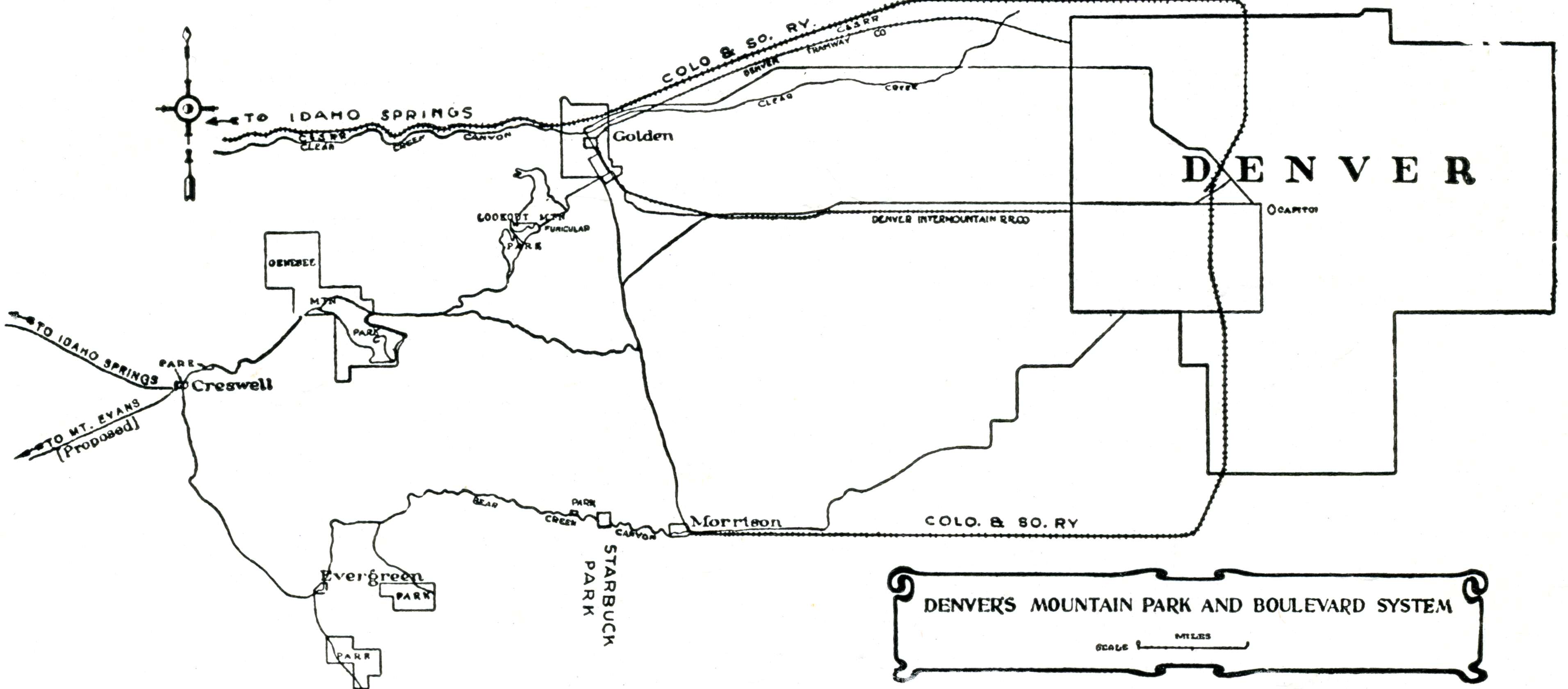
Highways: Sixty miles of mountain boulevards and approaches already constructed, with additional drives under construction and in prospect. Maximum cost per mile, $20,000. (See map on page 14.) Circle route by way of Creswell from the Pioneer Monument, Denver, and return, 63 miles.
Grades and Curves: Maximum grade in the mountains, six per cent. Sharpest curve is based on a radius of fifty feet. Usual width of highway, twenty feet-enough to permit two large vehicles to pass with ease. Exposed points are protected by masonry walls or anchored steel cables. Highway is provided throughout with a thorough system of drainage.
Features: The sky-line drive over Lookout Mountain drops ultimately into the cañon of Bear Creek, a famous trout stream, along which several of Denver’s millionaires have built summer homes. Shelters, fire-places, comfort stations and picnic grounds, provided with pure mountain water, occur at convenient intervals. Animal park of 135 acres, on west slope of Genesee Mountain, contains wild buffalo, elk, deer and other untamed animals.
Elevations: Denver, 5,280 feet; Golden (Main Street), 5,675 feet; Spring House, Lookout Mountain Drive, 7,045 feet; Wildcat Point, 7,300 feet; Lookout Mountain, 7,342 feet; Colorow Point, 7,500 feet; Genesee Peak, 8,270 feet (3,000 feet higher than Denver); Creswell (Bergen Park), 7,862 feet; Evergreen, 7,005 feet; Morrison (Main Street), 5,659 feet.
TRANSPORTATION AND
ROUND-TRIP FARES
- WILDCAT POINT and SUMMIT OF LOOKOUT MOUNTAIN, via C. & S. Ry. and auto, $1.50.
- Via trolley and automobile, $2.00.
- Via automobile all the way, parties of four or more, $2.50 each (minimum of four passengers).
- Via special observation car and automobile, $1.50.
- Via trolley to GOLDEN, automobile and Funicular Railway, $1.
- Circle Trip, 70 miles, via automobile, $5.00.
- Via C. & S. Ry. to MORRISON and automobile to STARBUCK PARK, $1.00.
- To other points in BEAR CREEK CANON, via Morrison, from $1.75 to $4.00.
- Circle Trip, 70 miles. Via C. & S. Ry. to MORRISON, auto to GOLDEN and rail to DENVER. Or via C. & S. Ry. to GOLDEN, auto to MORRISON and rail to DENVER, $3.00 round trip.
- Via C. & S. Ry. to MORRISON and PARK OF RED ROCKS, 50c and 75c.
- Via C. & S. Ry. or trolley to GOLDEN, 50c; CASTLE ROCK, $1.00.
Further information and literature on Thirty-eight Scenic Trips including Fourteen One-Day Trips mailed free:
TOURIST BUREAU
715 SEVENTEENTH STREET
DENVER, COLO.
